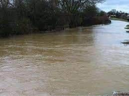
Council to splash out on flood reduction plan for Milton Keynes - including clamping down on brownfield developments
and live on Freeview channel 276
The council is proposing to spalsh out on a new flood risk management plan, which uses a mixture of digital and on-the-ground solutions.
MK Council’s Cabinet is set to approve the plan tomorrow (Tuesday) and it will set out intentions to work even more closely with partners and communities to assess and respond to flood risks.
Advertisement
Hide AdAdvertisement
Hide AdThe points considered in the plan include adapting MK’s local planning policy, with particular focus on brownfield development sites and the risks of making flooding worse.

Goverment strategy documents state: “Because much past industrial development took place alongside rivers on suitable flat land, some brownfield sites will be potentially vulnerable to flooding....What was suitable for industry in the past may well not be suitable for housing today".
Mk Council further plans to use more digital technology, with high tech sensors installed in flood risk areas to send early alerts. Workers will use mobile devices to measure water flow and also ensure good maintenance of “essential flood infrastructure” such as drains and gullies.
Cllr Wilson-Marklew, Cabinet member for Climate Change and Sustainability, said: “Climate change is already having a very real impact on the severity of rainfall in Milton Keynes, which sharply increases the chances of flooding.
Advertisement
Hide AdAdvertisement
Hide Ad"This extreme rainfall is out of our short-term control, but we can take sensible steps to reduce flood risks, and help residents and businesses be ‘flood prepared’.
It’s important that we set out our plans so partners and communities can understand the risk of flooding, and how they can contribute to our work to reduce this risk.”